Mid Fall in the Barron Canyon
Last Monday (2007 October 22), Bob and Diana went on a day trip by canoe through the Barron Canyon on the Barron River in Algonquin Park. It was a repeat of the trip we did six months ago (see Early Spring in the Barron Canyon), but this time the objective was solely to take advantage of a beautiful fall day. Shortly after 9:00 a.m., we started at the launch point just above Squirrel Rapids and travelled upstream, portaging around Cache Rapids and paddling through the canyon to the foot of the Brigham Chute portage. After backtracking a short distance and eating lunch in the canyon, we retraced our morning route to arrive back at the start point a bit after 3:00 p.m.
2007 October 22
Bob preparing the canoe at the Squirrel Rapids access point. When we came this way in the spring, the water was right up to the base of the cedar trees. (Comparison here).
On the Barron River, approaching Cache Rapids.
It was a beautiful day, clear and sunny. When we started out, the temperature was around 6C, but soon began to warm up as the sun rose. Much of the time the river was glassy calm, with only occasional light winds.
The portage around Cache Rapids. The trail is a little rough and rocky in places, but not too bad.
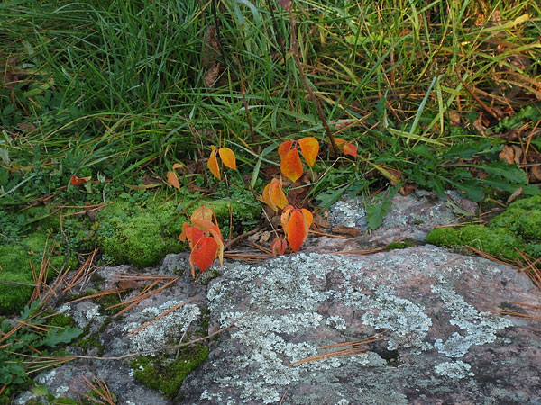
Poison Ivy on the portage around Cache Rapids -- very colourful in the fall. If you're sensitive to Poison Ivy, you need to be careful throughout this route; the plant is quite prevalent. Be especially careful where you set your packs down (or where you sit) at the upstream end of the Cache Rapids Portage and the downstream end of the Brigham Chute portage. There are also patches of Poison Ivy along the north shore of the river in the canyon.
A swampy area along the shore of the Barron River, near the mouth of Ignace Creek.
Scattered birch trees provided spots of yellow in the canyon, complementing the orange Xanthoria lichen on the cliff face.
Looking upstream towards the highest elevation along the northern rim of the canyon. The walking trail visits the cliff edge at that point.
The walking trail to the canyon rim runs partway along the top of this cliff. In the middle of the day at this time of year, the sun does not reach the bottom of the canyon for most of its length. The shadow of the southern rim of the canyon is very evident in this photo.
The northern cliff face of the canyon.
Our usual lunch spot was in the shade, as was most of the river shore. We did find one place that was illuminated by the sun shining through a notch in the southern rim of the canyon. It was a bit cramped, but pleasantly warm.
A spot of colour visible from our lunch spot.
The top of the canyon.
While enjoying the sights at te bottom of the canyon, we were being photographed from the top. Just by chance, we met the photographer at the takeout at Squirrel Rapids and he kindly sent us a copy of this photo. (Photo courtesy of James Sherlock, Eganville.)
The southern cliff face of the canyon. Although it was in the shade, the rock was illuminated by sunlight reflected from the north wall.
Looking downstream towards the lower end of the canyon.
Back at Cache Rapids. The flow in the river was much less than in the spring, as can be seen by comparing the same view from April. Most of the small creeks and waterfalls we had observed in the spring were completely dry or showed only traces of water. Hardwood Creek was the only falls with any significant flow.
Heading home. Like the morning drive in, this part of the trip involved dodging the ridge left in the middle of the road by the grader, and keeping an eye out for the many trucks hauling logs out of the park.
By late afternoon, the temperature had reached 25C at Petawawa (and on our front porch) -- only three degrees shy of the record high for the date.
Related Pages
The Barron River -- Some Photographs
Some photographs from an early May solo canoe paddle on the Barron River in Algonquin Park, starting at Squirrel Rapids, passing by Cache Rapids, through the Barron Canyon, and then on to Brigham Chute.
The Other Barron Canyon
An account of a canoe outing to First Chute on the Barron River and the other Barron Canyon
High Falls at High Water
The High Falls area of the Barron River, near Achray in Algonquin Park, provides striking scenery and a natural water slide. It is especially impressive in the early Spring
Do Black Bears Swim?
An account, with photographs of two black bears -- Ursus americanus -- swimming across Grand Lake in eastern Algonquin Park.
To High Falls and the Water Slide
An account, with photographs, of visiting High Falls and the water slide on the Barron River in Algonquin Park the hard way -- by canoe from High Falls Lake.
The Hawk Trail
A gallery of photos from along the Hawk Trail in the Petawawa Research Forest
The Debris at the Bottom of the Pond
A beaver dam on Maunsell Creek in the Petawawa Research Forest has burst and washed out Bypass Road. The partially drained beaver pond reveals evidence of the previous presence of some sort of building or structure. This page presents a gallery of photos of the revealed evidence.
Turkey Vulture
Photos of a turkey vulture, Cathartes aura, on the Quebec shore of the Ottawa River near Point Alexander.
A Walk to Ghost Lake in Algonquin Park
Some photos from a hike through the Rana Lake Red Oak Nature Reserve in Algonquin Park, starting from the Brent Road at Rana Lake, walking to Pan Lake and then following the portage to Ghost Lake,
passing the site of the old Brent fire tower en route
The Story of a Canoe
Our reliable old 15 ft lightweight Grumman Canoe was severely damaged this past winter. While repairable, we realize with regret that we will probably never paddle it again. Its story is related here.
Ooze Lake
An account, with photographs, of a visit to Ooze Lake in Eastern Algonquin Park, describing its ecology and an encounter with a cow moose and calf.
Trip Log - Brent, Nipissing River, Catfish lake
Diary and Photos from a four day / three night solo caoe trip from Brent on Cedar Lake in Algonquin Park, up the Nipissing River, across through Luckless Lake to Catfish Lake and then back to Brent through Narrowbag Lake and the Petawawa River
Lost
An account of an early spring walk in the bush during which, I get lost and some observations on the utility of a gps.
Early Spring along the Basin Depot Road in Algonquin Park
An account with photographs of exploring two walking trails off the Basin Depot Road in Algonquin Park: the McGuey Farm and Bridge Dam Trail, and the High Falls Trail. Both of these trails lead to historic spots along the Little Bonnechere River.
The Chalk River
An account, with photographs of canoeing the Chalk River between the Bronson Road and Corry Lake
A Public Archaeology Day at Basin Depot, Algonquin Park
On Saturday 2009 October 03, The Friends of Bonnechere Parks and the Ottawa chapter of the Ontario Archaeology Society hosted a Public Archaeology Day at Basin Depot in Algonquin Park. This was part of a week-long investigation of the site under the direction of licensed archaeologist Ken Swayze, extending the work done in previous excavations during the 1990s. Some photos from the day are presented here.
Track and Tower Trail
An account, with photographs, of a late fall hike around the Track and Tower Trail in Algonquin Park.
An Early Spring Hike to Eustache Lake and Wagtail Lake
In early May 1982, and again on Easter weekend in April 1984, Diana and Bob hiked into Eustache Lake and Wagtail Lake, starting at the Lake Travers Station and then returning along the Petawawa River, as an early season overnight trip.
Return to the Brent Crater
An account with photos of exploring the Brent Crater Trail in Algonquin Park with particular emphasis on the limestone gully on Muskwa Creek and the cedar swamp.