
Exploring Eastern Algonquin Park via the Achray Road
We were recently asked about opportunities for short trips and expeditions in Eastern Algonquin Park accessible via the Sand lake Gate. On this page, we are expanding on my reply to that query and providing links to pictures and information elsewhere on this site.

Heading into Eastern Algonquin Park — approaching the Sand lake Gate on the Achray Road.
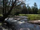
The Barron River and Canyon
The Barron Canyon is one of the scenic beauties of eastern Algonquin Park. It is easily explorable as a day trip, starting from Squirrel Rapids, paddling up the Barron River and through the canyon to the foot of the Brigham Chute Portage and return. It only involves a single portage (but done twice) around Cache Rapids. A nice trip but potentially busy. Probably best done on a weekday, avoiding July and August.

The Barron River — Some Photographs
Some photographs from an early May solo canoe paddle on the Barron River in Algonquin Park, starting at Squirrel Rapids, passing by Cache Rapids, through the Barron Canyon, and then on to Brigham Chute.

Mid Fall in the Barron Canyon
An account, with photographs, an mid fall canoe trip in the Barron Canyon.

Early Spring in the Barron Canyon
An account, with photographs of an early spring canoe trip in the Barron Canyon.
Opalescent Lake / High Falls Lake Loop from Brigham Lake Access
Another good day trip, but one that involves a reasonable amount of portaging is to start at the Brigham Lake Portage off the Achray Road. Paddle downstream on the Barron River to Brigham Lake and then portage over the hill to Opalescent Lake and continue paddling and portaging to Ooze Lake and High Falls Lake. High Falls Lake is a pretty lake and gives you access (albeit difficult) to the bottom of High Falls and also the falls on the branch of the Barron flowing out of St. Andrews Lake. Return to your starting point by following the Barron River downstream via The Cascades. The carry from the river back up to the car is a bit of a brute.
Opalescent Lake also provides access to Cork Lake, another possible day trip destination.
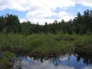
Ooze Lake
An account, with photographs, of a visit to Ooze Lake in Eastern Algonquin Park, describing its ecology and an encounter with a cow moose and calf.
High Falls
The natural water slide at High Falls is very popular. It is accessible by canoe from Achray via Stratton Lake, and on foot via the Eastern Pines Hiking Trail, or more easily by following a trail that starts from the Achray Road a few hundred meters west of the Brigham Lake Access parking lot. It is also accessible by canoe via High Falls Lake, but this route is not recommended.

High Falls at High Water
The High Falls area of the Barron River, near Achray in Algonquin Park, provides striking scenery and a natural water slide. It is especially impressive in the early Spring

To High Falls and the Water Slide
An account, with photographs, of visiting High Falls and the water slide on the Barron River in Algonquin Park the hard way — by canoe from High Falls Lake.

Where are "The Cascades"?
Some comments on the place names 'The Cascades' and 'High Falls' in eastern Algonquin Park
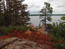
St. Andrews Lake / Rouge Lake / St. Francis Lake / Tarn Lake
St. Andrews Lake is easily accessible from Achray via Stratton Lake; only two short portages are involved. St Andrews is a pretty little lake with some scenic low cliffs on the eastern shore. Along the portage from St. Andrews Lake to High Falls Lake, there is evidence of the previous logging days: A sunken pointer boat at the top; river "improvements", also near the top; and supposedly the remains of a timber slide at the bottom.
St. Andrews Lake also provides access to St. Francis Lake (via Rouge lake), Tarn lake and Marie Lake.

Trip Log - St. Francis Lake and High Falls Lake
A description with photos of a two night canoe trip in eastern Algonquin Park, from Achray to St. Francis Lake and High Falls Lake.

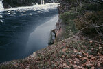
The Cliff at Tarn Lake
An account, with photographs, of a round trip hike from St. Andrews Lake in Algonquin Park, crossing the portage to Tarn Lake and then bushwhacking up the cliff in order to determine if indeed that clifftop was the site of Tom Thomson's painting, 'View from a Height'

Basking Snakes at St. Andrew's Lake
Photograph of snakes, basking in the sun at St. Andrew's Lake in Algonquin Park
Carcajou Bay / Carcajou Creek / Spectacle Lakes / McDonald Creek
From Achray, you can paddle straight across Grand lake and explore Carcajou Bay. There is another "High Falls" at the top of Carcajou Bay. If you portage around the falls, you can explore upstream on Carcajou Creek or alternatively check out the Spectacle Lakes. There used to be a recognized route down Carcajou Creek from Little Carcajou Lake but it is no longer maintained and may not be passable. Carcajou Creek also provides access to McDonald Creek and beyond.

The Jack Pine
Photographs of a jack pine bearing an uncanny resemblance to that in the painting 'The Jack Pine' by Tom Thomson

A Day Trip out of Achray to McDonald Lake
An account with photos and audio clips of a day trip in eastern Algonquin Park, from Achray to McDonald Lake.

Exploring Carcajou Creek
Some notes from exploring Carcajou Creek in eastern Algonquin Park.
Trip Log - Achray to Carcajou Lake via the Spectacle Lakes and Returning via Carcajou Creek
Some notes (no photos) from a one night canoe trip in Algonquin Park from Achray to Carcajou Lake via the Spectacle Lakes and then returning the next day to Achray via Carcajou Creek. These notes provide some limited additional information about the now abandoned canoe route down Carcajou Creek from Little Carcajou Lake.
Grand Lake
Another day trip out of Achray is to paddle up to the top of Grand Lake. Once you get up to the top half of Grand Lake, you are unlikely to see anyone. No portaging on this trip but you wouldn't want to do it on a windy day.
Drought
A photographic account of the effects of the 2012 summer drought around Achray on Grand Lake in Algonquin Park.

Windbound on Grand Lake
An account with photographs of a pleasant afternoon spent windbound, at the Jack Pine site on Grand Lake in Algonquin Park.
McManus Lake to Whitson Lake
Another interesting day trip is to start at McManus Lake and paddle upstream on the Petawawa River to the top of Whitson Lake. No portaging is required if you are prepared to wade the fast sections of the river between the lakes. Whitson lake is worth a visit because the vegetation is so different from anywhere else in the vicinity.
Eustache Lake
You can drive in to the old train station location at Lake Travers and then follow the abandoned railbed west to the Petawawa River. From there you can pickup the portage trail into Eustache Lake.

A Hike to Eustache Lake
An account with photographs of a hike to Eustache Lake in Algonquin Park.
Trip Log - An Early Spring Hike to Eustache Lake and Wagtail Lake
In early May 1982, and again on Easter weekend in April 1984, Diana and Bob hiked into Eustache Lake and Wagtail Lake, starting at the Lake Travers Station and then returning along the Petawawa River, as an early season overnight trip.
Lake Travers
Lake Travers is easily accessible from the Achray road, although it is a long drive. It is the usual starting point for overnight trips down the Petawawa River to McManus Lake, but it is also a destination in its own right.

Trip Log - Exploring Lake Travers in Algonquin Park
A description, with photos and trip diary, of an exploration of Lake Travers in Algonquin Park.

Exploring the Pembroke Lumber Company Site
An account with photographs of a hike into the old mill site of the Pembroke Lumber Company on Lake Travers in Algonquin Park.
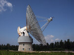
Open House at The Algonquin Radio Observatory
On July 19, 2008, we attended an open house at the Algonquin Radio Observatory (ARO) at Lake Travers (Lake Traverse) in Algonquin Park. The highlight was a tour of the 46 metre (150 foot) radio telescope. Some photographs of the Algonquin Radio Telescope and associated residence are presented here.
Sec Lake
Sec Lake is another easy access lake off the Achray Road. It is also possible to do a loop through Wet Lake and Norm's Lake, but that is something that we've yet to do.
Wenda Lake
You can combine a hike with paddling by starting at Achray on Grand Lake, paddling part way up the lake, stashing your canoe in the bush and then hiking over the portage to Wenda Lake (returning the same way). If you're going to do this, it is probably best to enquire at the Sand Lake Gate to ensure that no one is staying at the Wenda Lake cabin. The portage leads directly to the cabin and doesn't provide much in the way of alternative destinations.
Similar paddling and hiking trips are possible into Rowan Lake and into Tarn Lake (via St. Andrews Lake). We've yet to do the former. When we were younger, we did the day trip into Tarn Lake a couple of times, but not in a long time.
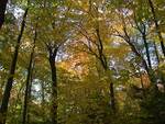
Wenda Lake Hardwoods
An account, with photographs of visiting Wenda Lake and the Wenda Lake Hardwoods
Berm Lake Trail and Eastern Pines Hiking Trail
Starting from Achray, the Berm Lake Trail provides a pleasant day hike around Berm Lake.

An Early Fall Hike Around Berm Lake and Johnston Lake
An account, with photographs of an early fall hike around Berm Lake and Johnston Lake in eastern Algonquin Park
Sources
Donald L. Lloyd (2000); Canoeing Algonquin Park, Published by D.L. Lloyd. Distributed by Hushion House Publishing Ltd. Toronto.
Michael W.P. Runtz (1993), The Explorer's Guide to Algonquin Park, Stoddard Publishing Co. Ltd.